Опубликован: 12.12.2015 | Доступ: свободный | Студентов: 689 / 118 | Длительность: 15:42:00
Специальности: Системный архитектор, Разработчик интернет-проектов
Лекция 10:
Отображение координат выбранного объекта
< Лекция 9 || Лекция 10 || Лекция 11 >
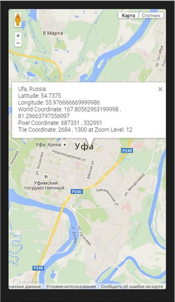
Для оптимизации скорости вывода изображений карты Google строятся из небольших плиток (tiles) размером 250?250 пикселов. У каждой плитки есть адрес. Google Maps JavaScript API позволяет отображать географические координаты выбранного объекта и номер плитки. В следующем примере мы продемонстрируем такие возможности. Создайте базовый веб-проект geo2. В файл index.html введите следующий код.
<!DOCTYPE html>
<html>
  <head>
    <title>Showing pixel and tile coordinates</title>
    <meta name="viewport" content="initial-scale=1.0, user-scalable=no">
    <meta charset="utf-8">
    <style>
      html, body, #map-canvas {
        height: 100%;
        margin: 0px;
        padding: 0px
      }
    </style>
    <script src="http://maps.googleapis.com/maps/api/js?key=AIzaSyBhwqeicLVNk2L6M8Mo7EzgupjUvJPher4&sensor=TRUE"></script>
    <script>
var map;
var TILE_SIZE = 256;
var ufa = new google.maps.LatLng(54.7375, 55.97666667);

function bound(value, opt_min, opt_max) {
  if (opt_min != null) value = Math.max(value, opt_min);
  if (opt_max != null) value = Math.min(value, opt_max);
  return value;
}

function degreesToRadians(deg) {
  return deg * (Math.PI / 180);
}

function radiansToDegrees(rad) {
  return rad / (Math.PI / 180);
}

/** @constructor */
function MercatorProjection() {
  this.pixelOrigin_ = new google.maps.Point(TILE_SIZE / 2,
      TILE_SIZE / 2);
  this.pixelsPerLonDegree_ = TILE_SIZE / 360;
  this.pixelsPerLonRadian_ = TILE_SIZE / (2 * Math.PI);
}

MercatorProjection.prototype.fromLatLngToPoint = function(latLng,
    opt_point) {
  var me = this;
  var point = opt_point || new google.maps.Point(0, 0);
  var origin = me.pixelOrigin_;

  point.x = origin.x + latLng.lng() * me.pixelsPerLonDegree_;

  // Truncating to 0.9999 effectively limits latitude to 89.189. This is
  // about a third of a tile past the edge of the world tile.
  var siny = bound(Math.sin(degreesToRadians(latLng.lat())), -0.9999, 0.9999);
  point.y = origin.y + 0.5 * Math.log((1 + siny) / (1 - siny)) *
      -me.pixelsPerLonRadian_;
  return point;
};

MercatorProjection.prototype.fromPointToLatLng = function(point) {
  var me = this;
  var origin = me.pixelOrigin_;
  var lng = (point.x - origin.x) / me.pixelsPerLonDegree_;
  var latRadians = (point.y - origin.y) / -me.pixelsPerLonRadian_;
  var lat = radiansToDegrees(2 * Math.atan(Math.exp(latRadians)) -
      Math.PI / 2);
  return new google.maps.LatLng(lat, lng);
};

function createInfoWindowContent() {
  var numTiles = 1 << map.getZoom();
  var projection = new MercatorProjection();
  var worldCoordinate = projection.fromLatLngToPoint(ufa);
  var pixelCoordinate = new google.maps.Point(
      worldCoordinate.x * numTiles,
      worldCoordinate.y * numTiles);
  var tileCoordinate = new google.maps.Point(
      Math.floor(pixelCoordinate.x / TILE_SIZE),
      Math.floor(pixelCoordinate.y / TILE_SIZE));

  return [
    'Ufa, Russia',
    'Latitude: '   + ufa.lat(),
    'Longitude: '  + ufa.lng(),

    'World Coordinate: ' + worldCoordinate.x + ' , ' +
      worldCoordinate.y,
    'Pixel Coordinate: ' + Math.floor(pixelCoordinate.x) + ' , ' +
      Math.floor(pixelCoordinate.y),
    'Tile Coordinate: ' + tileCoordinate.x + ' , ' +
      tileCoordinate.y + ' at Zoom Level: ' + map.getZoom()
  ].join('<br>');
}

function initialize() {
  var mapOptions = {
    zoom: 12,
    center: ufa
  };

  map = new google.maps.Map(document.getElementById('map-canvas'),
      mapOptions);

  var coordInfoWindow = new google.maps.InfoWindow();
  coordInfoWindow.setContent(createInfoWindowContent());
  coordInfoWindow.setPosition(ufa);
  coordInfoWindow.open(map);

  google.maps.event.addListener(map, 'zoom_changed', function() {
    coordInfoWindow.setContent(createInfoWindowContent());
    coordInfoWindow.open(map);
  });
}

google.maps.event.addDomListener(window, 'load', initialize);

    </script>
  </head>
  <body>
    <div id="map-canvas"></div>
  </body>
</html>
< Лекция 9 || Лекция 10 || Лекция 11 >

